Century of EndeavourA Future for Dublin?(c) Roy Johnston 2002(comments to rjtechne@iol.ie)Text of an essay by Roy Johnston, dated 25/6/91, which won the Irish Planning Institute prize in 1991. I am going to begin with a vision of a possible future for Dublin, and follow with some suggestions for how the vision might be implemented. The vision involves building on the experience of other cities abroad where civilised urban living has continued to exist despite the pressures created by the private motor vehicle.
The VisionI see a city as a network of foci, or 'urban villages', rather than a centre where people work and sometimes want to go at night, surrounded by dormitory suburbs.In the vision, most people live and work in or near their 'village', and are in walking or cycling distance of shops and services. Those who work in other 'villages' are able to get to their places of work using an express public transport system which connects all 'villages', in a mesh, clearly mapped, like the Paris Metro. Those whose work requires that they have mobility in the city during the day, for business appointments etc, are able to do so with the aid of the express public system, which is frequent and punctual, and supported locally at some key nodes by a supplementary 'black-taxi' system, which focuses on the 'village' centres, the nodes of the urban express mesh.
Present Reality and the VisionThis vision actually does touch reality at some points. I live in Rathmines; shops are in walking distance; there are schools, a 3rd-level college, a cinema; I rarely have to go outside Rathmines for day-to-day needs. Apart from the journey to work, I might want to go to a concert (Kilmainham, Earlsfort Terrace, the Centre Point), or to make a business contact (TCD, UCD, Bolton St, NCAD, Eolas or DCU in Glasnevin; my interest is in finding economic applications for the results of research).I lived for a period in London, which city is only viable at all because of its structure as a network of 'villages' connected by a multi-nodal mesh underground rail system. London has many faults, mostly because it is too big altogether, but it is livable-in, thanks to its 'village' network structure. Let us use aspects of this to help build our Dublin vision. The Dublin reality however, in its Rathmines embodiment, falls short of the vision because of the lack of proper reliable urban transportation. For the journey to work in Blackrock, I use mostly the bicycle (25 minutes), and, if wet, the car (15 minutes). On one occasion when I was grounded due to a puncture, the encounter with Bus Atha Cliath was a time-consuming culture-shock; it took about an hour and a half and was a trigger for this article. For a journey to the centre of the city, the bus is feasible though unreliable on the outward journey, but totally frustrating for the return, due to the existence of several low-frequency routes all with different starting-points. To get to Glasnevin or Kilmainham by bus, it would be necessary to change at the centre, and to find the central contact-point for the other route is totally impracticable for an occasional user, especially in a time-bound situation. So out comes the car.
Two components of Urban ViabilityLet us get back to the vision, and consider its two main components: the city as a patchwork of 'villages', and the express transport mesh.Which comes first? Does the mesh generate the villages, or does the urban transport system simply respond to demand? This should be studied historically. I am inclined to think that Rathmines, Ranelagh and Ballsbridge were prospering 'villages' when the trams were laid down, and their prosperity was reinforced when they became nodes on that part of the tram system which was mesh-like, where the 18 crossed the radial 8, 9, 10, 11, 12, 13, 14 and 15 routes. This key role for the 18 has been eroded in recent times, as the service level declined with the transition to buses and the build-up of traffic. In the new vision, a corresponding role needs to be re-developed, and I expand on this below. I see stages in the realisation of the vision. First, identify the potential 'village' nodes, then set up the mesh to connect them, and then be prepared to see the development of new 'village' nodes where the routes cross, and to facilitate this process.
The Urban VillagesLet us take a segment of the DART line between Blackrock and Lansdowne Road, and consider the stations. Each has the potential for servicing a village node, with residential, workplace, commercial and cultural roles. Aspects of these roles have begun to appear in walking-distance of all stations, most spectacularly in Blackrock, and also detectably at Sydney Parade and Booterstown. Sandymount has long-standing village status, and Lansdowne Road is at the core of an old-established business focus, and in reach of other village-like features.Let us consider the concept of the 'DART feeder' east-west bus-route. These have been introduced to link the DART to places like UCD and the Sandyford Industrial Estate. Their primary role however is as DART-feeder; they are not conceived as forming a high-profile mappable mesh with the north-south routes of the bus system. Let us enrich the DART-feeder concept and re-define it as an express route linking the 'villages' to the west of the 'DART villages', if I may so label the locations named above. Now let us get out the map, and identify plausible village-like nodes to the west, taking into account the constraints which would face the planner of east-west routes for express buses (ie buses with distance between stops comparable with the DART, and running at reliably scheduled times). The following foci suggest themselves: Lansdowne Rd: Pembroke, Ranelagh, Rathmines, Harold's Cross, Crumlin, Drimnagh... Sandymount: Donnybrook, Milltown, Rathgar, Terenure, Kimmage, Ballymount.... Sydney Parade: Belfield, Goatstown, Churchtown, Rathfarnham, Templeogue... Blackrock: Stillorgan, Dundrum, Willbrook, Firhouse.... Granted, the road system as it has evolved is not friendly to east-west linkages like these, but this is a problem for the road planners, who need to be brought in on the vision. We want roads which will support a scheduled express bus service in a situation where private vehicle traffic is being actively discouraged (more on this below), not 6-lane motorways.
The Inner and North CityThe inner city is currently dominated by the fact that all virtually all bus routes cross the city by O'Connell Bridge. This made sense when Dublin was a small radial city, on a village-like scale, and had a radial tram system, focused on Nelson's Pillar.In order to bring it into the vision, let us see if we can extend the DART- feeder principle, beginning with the east-west routes from the inner-city DART stations. Consider first linkages west from Pearse: there is an obvious one to Kilmainham via Thomas St: something like the existing 21 route. There is another feasible one via Adelaide Road and Dolphins Barn, along the SCR.; this would link with the terminus of the Harcourt St light rail system, when re-opened.There is a third via St Stephen's Green and the Coombe. West from Tara St we have the link to Heuston, the Park and Chapelizod. West from Connolly we have 2 possible routes, an outer one via the NCR and an inner one to Heuston via North King St. There is potential to open a station at Fairview/Clontarf, and run a route west along Griffith Avenue. A west route along Collins Avenue from Killester is feasible, and would open up a link with DCU in Glasnevin. Raheny could link to Coolock, Santry and Ballymun.
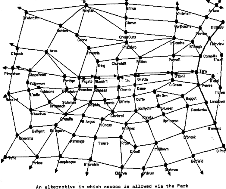
North-South RoutesOnce the east-west routes have been envisioned, and the 'villages' they service roughly identified, in the form of named recognisable (potentially Rathmines- like) locations, with one or more commercial, cultural, educational and other civilised services to offer, then we can look at the possibilities for linking them with north-south routes.We have the constraint that the DART is curved, looking eastwards. The Park similarly puts a constraint on the westernmost inner N-S route, suggesting that it should be curved looking westwards. (The westernmost N-S route of all need not be curved: Tallaght to Blanchardstown via the new toll bridge).The radial history of the growth of the city has made it impossible to impose a rectangular mesh. Who wants a rectangular mesh; anyway. We are not in New York. (There is perhaps an alternative approach depending on one's attitude to the Park. A route from Finglas to Ballyfermot via Ashtown and Chapelizod would enable someone living in Finglas to look for a job in Ballyfermot without having to depend on a private vehicle to get there. And why should someone in Castleknock be deprived of access to east-west routes. So I am presenting an alternative map, with the Park exclusion constraint relaxed. Two routes crossing in the neighbourhood of Aras an Uachtarain, at frequencies of 15 or 20 minutes, would improve access for people to the Presidency in its increasingly open role.) The point is that if we use most or all the Liffey bridges for the N-S routes, we in effect spread the centre of Greater Dublin out evenly over the whole inner city, instead of concentrating it pathologically into O'Connell St, where due to congestion it is declining. Let us therefore suggest a route Naas Rd, Kilmainham, Parkgate, Prussia St, Cabra, Ashtown. Kilmainham deserves focus status; it now has a major cultural centre and has always been a commercial focus. Then let's try Tallaght, Greenhills, Ballymount, Dolphins Barn, James's Gate, Blackhall Place, Phibsborough, Finglas... (yes I know the Liffey crossing here is tricky, and the streets are narrow, but perhaps with judicious one-way routing it would be possible to bring about a situation where the existing 'village' centred round Thomas St could become an active developing node on the mesh, bringing prosperity back to the Liberties). How about Tallaght, Templeogue, Terenure, Harold's Cross, Old City, Phibsborough, Glasnevin, Ballymun. We are not at O'Connell Bridge yet. Next we have Churchtown, Rathgar, Rathmines, Georges St, Capel St, Drumcondra, Santry... Lets even send the Dundrum Ranelagh route across Capel St northward, and reserve O'Connell Bridge for routes coming in via Leeson St and Morehampton Road. There is scope for a route to the east of the railway taking advantage of the toll-bridge. The inner-city nodes on this mesh include the existing Grafton St, Henry St and Phibsboro 'villages', but many new ones are added, where east-west and north-south routes cross. Some nodes already have foci, with growth potential for urban civilisation: the DIT Colleges, the DCU, the Centre Point; I have already mentioned Kilmainham, and Thomas St with the NCAD. Where nodes have come into existence, foci would develop, existing shops would prosper, business would establish itself once the workforce could get there without getting stuck in the traffic, and without generating a parking problem.
The User's View of the Transport SystemOnce the transport route system has been liberated from the congestion of O'Connell St, it would be possible to map it transparently. At every node and stopping-point of the system, there would be on display a map, constructed along the lines of the Paris Metro map, with every node and intermediate point of the map recognisably named. It could be printed in diaries, as is the London Underground on imported ones.One possible mesh system generated by the foregoing arguments is illustrated in the accompanying map. You could get from anywhere to almost anywhere else over the greater Dublin area with one change, in a situation where there is at each change-point only one or at most two other corresponding routes, in a well-mapped situation. The radial micro-bus or 'black taxi' services, mentioned in the introduction, would be an important support service in the neighborhood of the central business foci. Ticketing would be in advance, from shops near, and vending machines at, the stops. Tickets would be cancelled on the bus, with a time-stamp, giving say half an hour's travel per unit. There should be no need for the drivers to handle money (the present system where the bus stops all traffic behind while the driver takes money and gives change is little short of ridiculous). Scheduling should be in the form of a listing at each stop of the minutes past the hour at this stop of the base-service in each direction, with indication of doubling frequency between certain times.
Networked VillagesIf Dublin can implement a vision such as I have outlines, in which all its 'villages' are equally accessible, and in which business appointments can be kept using the public system, then Dublin has a future.The phasing in of the new system would need to be well planned, with lots of TV coverage, and active support by fashion-leaders. Charging private vehicles for the use of road-space at specified times is a feasible tool. People would need some active encouragement to make the changeover from traffic-jam dominated dependence on their own vehicle to willing dependence on a reliable scheduled public system. To strengthen the identity and viability of the 'villages', it would make sense to equip them with civic centres, and make them also foci for the new devolved district councils, contact-points for the citizen with government. This additional dimension needs to be explored as a separate issue, but it is appropriate to mention it here in passing, as urban planning, urban transport and local democracy all must form part of an integrated viable system. Finally, the foregoing is to be understood as a general framework, of which some components might be existing rail (DART, upgraded Maynooth line, or lines west from Heuston), others might be light rail or tram where appropriate, and the remainder express bus based on existing vehicles. The principle could be piloted using existing vehicles, provided the phase-over was properly managed, and the concept aggressively marketed.
Some navigational notes:A highlighted number brings up a footnote or a reference. A highlighted word hotlinks to another document (chapter, appendix, table of contents, whatever). In general, if you click on the 'Back' button it will bring to to the point of departure in the document from which you came.Copyright Dr Roy Johnston 1999
|